


 Buy & Sell
 Buy and Sell Card
Wingfoil
 KT Wing Drifter 90L- $450: Yesterday at 7:40pm by dwrex (0 replies)
 Re: 5.0 EZZY FLIGHT: Yesterday at 3:56pm by downwind dave (1 reply)
Windsurf
 2-piece mast bag for great price Yesterday at 3:18pm by GregK (0 replies)
 Re: Windsurfing kit and 2 sails 5 days ago by Cam (1 reply)
Kitesurf
 12m Ocean Rodeo Aluula Roam - Sold 8 days ago by Junior (0 replies)
 Re: 7m Ocean Rodeo Prodigy Gen... 8 days ago by SmallWaveSteve (1 reply)
 GPS Tracks
 GPS Track Card
 Pt.Holmes 12/09/25: Yesterday at 2:31pm at Comox Spit by mayday (16 km)
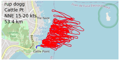
 RB Dec 07: 3 days ago at Ross Bay by rup_dogg (40 km)

 Donations
 Donation Card
 Benjibrentwood from Brentwood Bay: 3 days ago (94% to goal)
 john m: 4 days ago
- GoJoeGuy from victoria: 5 days ago
 Photos
 Latest Photos Card
 Wing: 11 days ago by ThePope (1 comment)
 Wing: 1 month ago by shaggy (2 comments)
 Windsurfing: 1 month ago by winddoctor (4 comments)
 News
News Nitinaht Lake Forecast
Hello All, This is it. We are closing down the shop at Lake Nitinaht. I loved reporting on the weather on a daily base, and I hope you found it useful. My plan is to be back next year and start reporting as soon as I get to the lake, sometimes middle to end of May 2026. I am looking...
 News
News Wing Rescue Technique
It had been requested that I post up a how-to for rescuing runaway wings. I've successfully done it at least once so I guess it makes me an internet expert on the topic. Please feel free to add any methods or insights to this thread. The following is what seemed to work for me the other day...
Marine Synopsis
Sailing Log Stats (Day 344)
| Sailor | Sessions |
|---|---|
| Highrocker | 177 |
| Bobson | 163 |
| ThePope | 126 |
| idefix | 124 |
| KUS | 119 |
| Spot | Days | Sessions |
|---|---|---|
| Ross Bay | 127 | 1014 |
| Nitinat Lk | 96 | 334 |
| Comox Spit | 95 | 96 |
| Clover Pt | 69 | 118 |
| Pipers Lgn | 61 | 176 |
| Activity | Days | Sessions |
|---|---|---|
| Wingfoil | 304 | 2026 |
| Windsurf | 180 | 391 |
| Windfoil | 155 | 202 |
| Kitesurf | 151 | 270 |
| Parawing | 40 | 50 |
| Period | Days | Sailors | TopSailor | TopActivity | TopSpot |
|---|---|---|---|---|---|
| Dec09 | 1 | 1 | - | Wingfoil | Comox Spit |
| Week | 2 | 11 | mayday | Wingfoil | Comox Spit |
| Dec | 9 | 27 | Windjunky | Wingfoil | Comox Spit |
| 2025 | 320 | 83 | Highrocker | Wingfoil | Ross Bay |
You are a guest ( Sign Up ? )
or post as a guest
-
This commment is unpublished.
 · 4 years agoOk, I am getting used to the new format now and really like my new avatar!
-
This commment is unpublished.
 · 4 years agoI appreciate the feedback. I know the new homepage is cluttered and I'm not that happy with the look of it. Also the sidebar info doesn't look great. I will work on it but I'm (clearly) not a web/graphic designer. Some bugs still, but the content is all here so it's getting closer... It does look better on mobile/tablet compared to desktop.
-
-
This commment is unpublished.
 · 4 years agoIt ok Dave. This new one works great :)
 -
This commment is unpublished.
· 4 years agoFYI the old site at bigwavedave.ca is not dead yet, I just broke it somehow. Hopefully it'll be back soon...
-
This commment is unpublished.
 · 4 years agoYa just checked that out the quicklook. Perfect!
 -
This commment is unpublished.
 · 4 years agoI really like the show all option and the quicklook for the forecast models!
 -
This commment is unpublished.
· 4 years ago
[quote=bwd]Is that on your ancient iPhone? :lol: :lol:
Edit: In Safari the names of the sites do not come up unless you scroll over it on the forecast one page.
-
This commment is unpublished.
· 4 years agoThanks for the comments Tsawwassen. I don't understand your last comment - screenshot?
-
This commment is unpublished.
· 4 years agoThe first image has no names then the second you can see Dallas Rd but that only comes up if the cursor is over it. I'm I making any sense? Just added a new image from Firefox, it looks great.
-
This commment is unpublished.
· 4 years agoIs that on your ancient iPhone? It's supposed to be white text on blue background but it is not putting the blue background in for some reason, so white text on white is a bit hard to see...
Edit: Fixed now? Let me know if you see anything else like that thx-
This commment is unpublished.
· 4 years agoLooks good now!
-
-
-
-
This commment is unpublished.
 · 4 years agoNobody here
- ← Previous
- ...
- Next →